
How to Find A Grave Using Google Maps
To find a monument or grave using GPS coordinates you will need a phone or other device with live mapping capabilities.
1) Find the record of the grave you wish to visit by using the Basic or Advanced Search Page of this website.
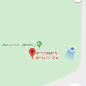
2) When looking at a grave record, scroll down to the "Google Maps Link" heading and then click "Find it on Google Maps."
3) Your device should open a mapping program that shows a red pin (the grave you want to visit) and a blue dot (where you are). You may need to zoom in or out of the map to see where your blue dot is in relation to the red pin.
4) Walk toward the red pin, keeping to the paths as much as possible and watching for obstacles.
Please note that using these coordinates will get you within approximately 10 feet of your intended destination, the difference being due to the limits of phone mapping systems. If you need exact burial locations, please contact the City of Oberlin.
Tips
1) You may have to give your phone or device permission to use your location or turn on Location Services.
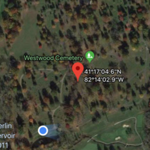
2) You may want to change your map view or layer to "satellite" to see the cemetery pathways.
3) The blue dot sometimes freezes – just walk around a bit to wake it up.
4) You may want to zoom in on your map for better accuracy as you get closer to your destination.
Thank you
To the volunteers who spent years gathering and entering these coordinates and Oberlin College Libraries staff members for integrating them into this database.